


Beginning on Saturday and continuing well into next week, two storms—including another extended atmospheric river event—will saturate most of California, increasing the possibility of flooding and landslides.
The state is still getting over a particularly strong storm that hit Southern California in early February, bringing record-breaking rainfall and hundreds of mudslides to Los Angeles and other areas.
The two storms aren’t expected to be as bad as the ones that hit early in February, but the continuous downpours and the second storm’s slow motion will make flooding a serious risk.
Flood watches are in effect for over 27 million people, spanning from Northern California to portions of the Los Angeles region.
The National Weather Service stated that although the first storm is predicted to be smaller than the second, it “will act as a primer, increasing soil moisture and causing the streams and rivers to rise before the heavier rain on Sunday” from the second storm. Early on Saturday morning, it will make its way toward the Northern California coast, where it will pour one to two inches of moderate rainfall over the course of the day. In Southern California and the Central Coast, just little rain is anticipated.
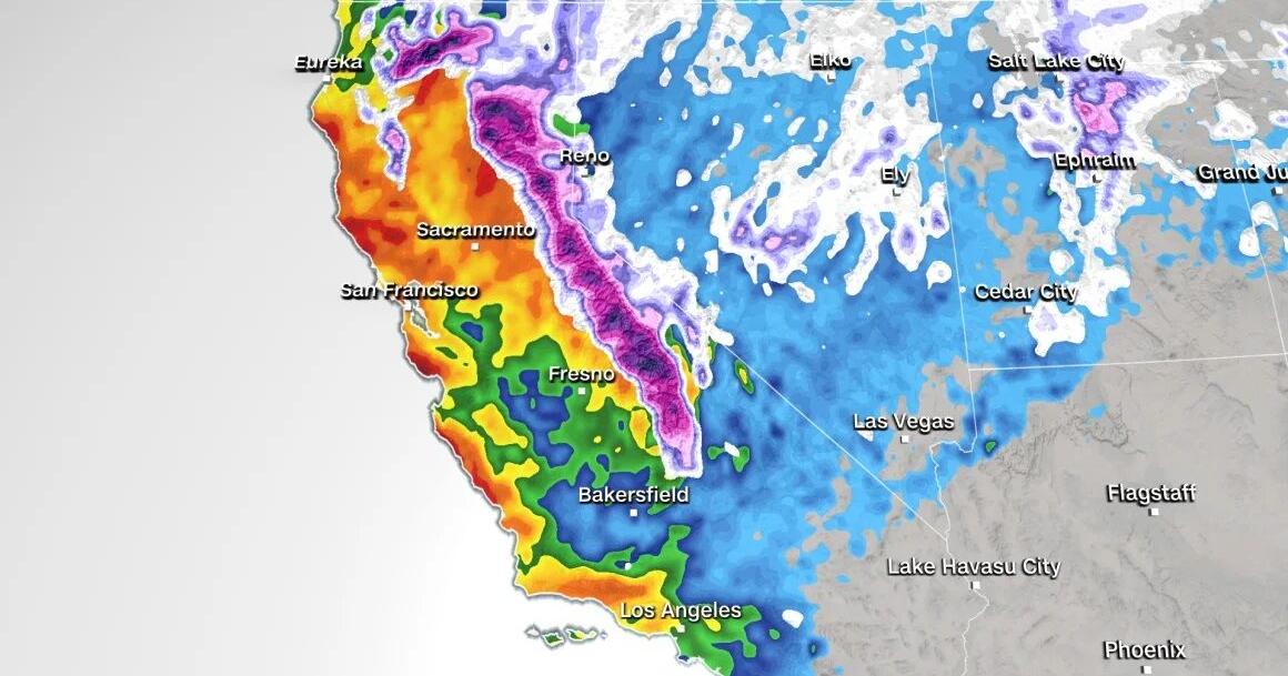
There is a greater chance of excessive precipitation through Wednesday throughout most of the state due to the second, stronger storm that is expected to arrive on Sunday afternoon and linger close to the coast into early next week.
Sunday is projected to be the most significant weather day in the northern section of the state, with 1 to 3 inches of rain predicted in the lowlands and 3 to 5 inches in higher altitudes.
The National Weather Service office in San Francisco stated, “Soils around the Bay Area are near saturation, so the rainfall will runoff quickly and likely contribute to numerous shallow landslides along areas of steep terrain.”
There will be wind gusts as well, but nothing quite as strong as the hurricane-force gusts that killed hundreds of thousands during the storm in early February. Sunday night into Monday are probably going to see wind gusts between 35 and 50 mph, which “could lead to more downed trees and potential power outages.”
The Central Coast and portions of Southern California will be covered by the strongest rain as it moves southward late Sunday and early Monday. In particular, Santa Barbara is at risk of flooding rain beginning on Sunday and continuing through Monday night, with a Level 3 of 4 forecast.
The heavy rain starts to fall on Monday afternoon and reaches Los Angeles, where there is a Level 2 of 4 risk of flooding from Tuesday until early Wednesday.
The Weather Prediction Center stated that “rainfall rates in this region have the potential to reach 0.5 to 1 inches per hour, with over 1 inch per hour rates possible.” From Sunday through Wednesday, 2 to 4 inches of rain are expected in coastal locations and 4 to 6 inches in higher elevations.
The National Weather Service office in Los Angeles stated that “this amount of rain along with last week’s totals will bring significant concerns for flooding and landslides.”
Higher altitudes are expected to receive more snowfall, even as the coast is expected to see heavy showers.
The storm on Saturday is predicted to produce 4 to 10 inches of snow by Sunday morning in high elevations of the southern Cascade mountains and the Sierra Nevada, making it the weaker of the two systems in terms of snow accumulation.
According to the National Weather Service office in Medford, Oregon, “Mount Shasta could easily see two feet of snow accumulation Saturday/Saturday night across their high terrain which may lead to some happy folks at the ski park.”
But there’s a lot more snow that second storm is expected to bring to the area.
In the Sierra Nevada, snowfall totals by Wednesday could be as high as 1 to 2 feet for regions above 5,500 feet, and as high as 4 feet for the highest summits.
The National Weather Service office in Sacramento issues a warning: “While the Warning is in effect, mountain travel is highly discouraged due to potential impacts, which include difficult to impossible travel conditions, snow covered roads, chain controls, reduced visibility, and road closures.”
I am a dedicated student currently in my seventh semester, pursuing a degree in International Relations. Alongside my academic pursuits, I am actively engaged in the professional field as a content writer at the Rangeinn website.